


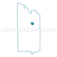
Breitung Twp. Voting District, St. Louis County, Minnesota
About
Outline

Summary
| Unique Area Identifier | 604273 |
| Name | Breitung Twp. Voting District |
| County | St. Louis County |
| State | Minnesota |
| Area (square miles) | 38.87 |
| Land Area (square miles) | 23.05 |
| Water Area (square miles) | 15.82 |
| % of Land Area | 59.30 |
| % of Water Area | 40.70 |
| Latitude of the Internal Point | 47.85016590 |
| Longtitude of the Internal Point | -92.25980200 |
Maps


Graphs
Select a template below for downloading or customizing gragh for Breitung Twp. Voting District, St. Louis County, Minnesota


Neighbors
Neighoring Voting District (by Name) Neighboring Voting District on the Map
- Eagle's Nest Twp. Voting District, St. Louis County, MN
- Greenwood Twp. Voting District, St. Louis County, MN
- Kugler Twp. Voting District, St. Louis County, MN
- Tower Voting District, St. Louis County, MN
- Unorg. 63-14 Voting District, St. Louis County, MN
- Unorg. Prct. 13, St. Louis County, MN
- Unorg. Prct. 20, St. Louis County, MN
Top 10 Neighboring County Subdivision (by Population) Neighboring County Subdivision on the Map
- Greenwood township, St. Louis County, MN (939)
- Breitung township, St. Louis County, MN (605)
- Birch Lake UT, St. Louis County, MN (505)
- Tower city, St. Louis County, MN (500)
- Northeast St. Louis UT, St. Louis County, MN (248)
- Eagles Nest township, St. Louis County, MN (242)
- Kugler township, St. Louis County, MN (175)